Sky Terrain Maps Aspen, Crested Butte & Maroon Bells - 4th Edition
Aspen, Crested Butte & Maroon Bells - 4th Edition
Couldn't load pickup availability
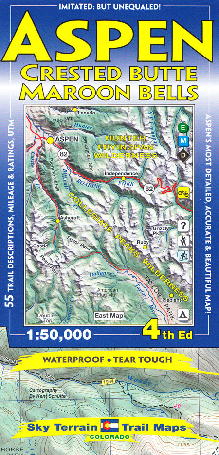
Sky Terrain Trail Maps Aspen, Crested Butte & Maroon Bells - 4th Edition is a 1:50,000 scale map that covers Ashcroft, Aspen, Capitol Peak, Castle Peak, Crested Butte, Conundrum Hot Springs, Frigid Air Pass, Gothic, Government Trail, The Grottos, Hunter Valley, Independence Pass, Marble, Maroon Bells, Oh-be-Joyful, Pearl Pass, Pyramid Peak, Redstone, Ruby, Rustler Gulch, Schofield Pass, Snowmass, Taylor Park & Pass, Yule Quarry and oh so much more — a total of 18 USGS quad maps.
Seven lofty 14,000-foot peaks: Capitol, Castle, Conundrum, Maroon, North Maroon, Pyramid and Snowmass Mt., plus large swaths of the White River National Forest and the Gunnison National Forest. A small slice of the San Isabel National Forest runs along the eastern edge of the map. The vast majority of the Maroon Bells Snowmass Wilderness is shown; while huge chunks of the Collegiate Peaks Wilderness and Raggeds Wilderness are also mapped. The whole SW section of the Hunter Fryingpan Wilderness, including the namesake headwaters are well revealed. And a big bit of the Mount Massive Wilderness stands out above Halfmoon Creek.
Specs
- Two maps cover 9 USGS quads each
- Each Map offers ideal coverage of the towns and nearby famous passes and mountain ranges
- Shading tints and contours enhance elevation cues and organize complex terrain
- Backcountry Ski Huts
- Trail rating symbols
- Key roads are also rated for road biking and mountain biking
- Singletrack symbols for mountain biking
- Trail descriptions including directions, trail lengths, elevation gains, noteworthy features and more
- Historic routes shown for reference
- Ideal contour levels (80 feet) set to improve visualization of terrain forms and maximize elevation information
- Careful mapping and graphic stressing of natural hydrography to improve comprehension of the terrain forms
- Numerous waterfalls and cascades published here for the first time
- Full UTM grid for easy use with GPS receivers
- Trails indexed to UTM grid
- Printed on waterproof, tear-tough material for years of hands-on use
SKU:0966550864-1123476504